
Tramping! Pic heavy!
-
Great shots mate, it's almost like I was there (without getting wet or having sore feet ;) ).

-
Thanks guys! You know I do it all just to take photos for you. ;)
@ToolJoe said:
Now I must add New Zealand to future travel list. Also, that white van is awesome 8). Shame there are none around in the states..The trusty Toyota Hiace is one of the most common vehicles here, especially in a city inundated with tradesmen for the rebuild. Mine is currently at 311000kms.
I love those old broad vans you have in the US - GMCs I think? The closest we have in shape is the CF Bedford (I always wanted one) but they are pretty much all worn out. -
Abel Tasman Inland Track: A three-day trip over the higher inland areas of the Abel Tasman National Park at the North end of the South Island (Te Wai Pounamu), New Zealand (Aotearoa). Less tourist-infested than the more popular Abel Tasman Coastal Track (which can also be accessed by kayak as documented here: /post/1032000).
<u>Abel Tasman Inland Track Day 1 03-10-2015: Marahau - Castle Rocks Hut</u>
We (my brother, two of his friends and I) started on the coastal track and after half an hour's walk took the Inland Track turnoff which climbed steadily up through the Kanuka:

Looking back to Marahau:


Fashioning a walking pole out of a dead Kanuka stick with my Wenger Ranger:

Adele Island:

Anchorage and Pitt Head. Marlborough Sounds and D'Urville Island beyond:


Holyoake Clearing Shelter:


Rimu tree:


After 7 hours walking we reached Castle Rocks Hut.
-
<u>Abel Tasman Inland Track Day 2 04-10-2015: Castle Rocks Hut - Awapoto Hut</u>
Tasman Bay from Castle Rocks in the morning:


Castle Rocks Hut. I stayed here and the others sleptin their tents:


Getting up to about 1000m:


Moa Park Shelter (lunch stop):

Water resupply:


Lots of windfall:


Finally we reached Awapoto Hut after 8 hours through forest with hardly any views.
-
Thanks for sharing, you are lucky indeed for having such beautiful areas to explore.
-
<u>Abel Tasman Inland Track Day 3 05-10-2015: Awapoto Hut - Totaranui</u>
Sunrise at Awapoto Hut:

Awapoto Hut:


View of Golden Bay as we descend:

Wainui Inlet:


Can you see the house?:

Wainui Inlet; Golden Bay beyond:


Through some farmland:

Kereru:


Nearly at Totaranui:

The campground at Totaranui, after 5 hours walking:

Where we waited for our Water Taxi home:

-
Some breath taking views. Question tho, are these huts pre arraigned? Or is it a first come first serve? Either way its nice theres shelter available for hikers. Also does the water have to be treated to be safe to drink?
-
@Aloha007 said:
Some breath taking views. Question tho, are these huts pre arraigned? Or is it a first come first serve? Either way its nice theres shelter available for hikers. Also does the water have to be treated to be safe to drink?Down on ther popular Coastal Track the huts are expensive and need to be pre-booked (as do tent sites - you may only camp at the official campsites to protect the environment).
Also I wouldn't touch the water there; Giardia is a real problem due to tourists defacating ON THE TRACKS which act as watercourses during rain and eventually end up in the creeks.Up here on the Inland Track however, the huts are known as "Backcountry Huts" and are really cheap: $5NZD per night (about $3USD?).
First come - first served. Each hut has around 8-10 bunks but I have heard of people sleeping on the floor or out on the verandah when full. They are simple and usually have a table, a woodfire, a stainless steel bench and a water source and longdrop outside.
We drank from the streams with no issues at all. On the second day there were no creeks near the track for most of the way so I carried 2 litres of water in two Camelbak bottles. -
<u>TABLELAND CIRCUIT 1</u>
Okay, I did this in Mid-Summer and it is now Mid-Winter so it has taken me six months to sort through all the photos and get them posted here. Photobucket doesn't like portrait photos taken on my phone and tries to rotate them so we are fighting back and forth, so apologies if that happens here.
Tableland is an area in the Upper Takaka River catchment of Golden Bay, which is at the Northern end of the South Island (Te Wai Pounamu or Te Waka a Maui) of New Zealand/Aotearoa.
<u>Tableland Circuit 1 Day 1: Cobb Dam Road - Balloon Hut</u>
Firstly, my gear list: (I don't have a PLB or GPS yet)

I drove up the Cobb Dam Road and past the Cobb Power House on the Takaka River:
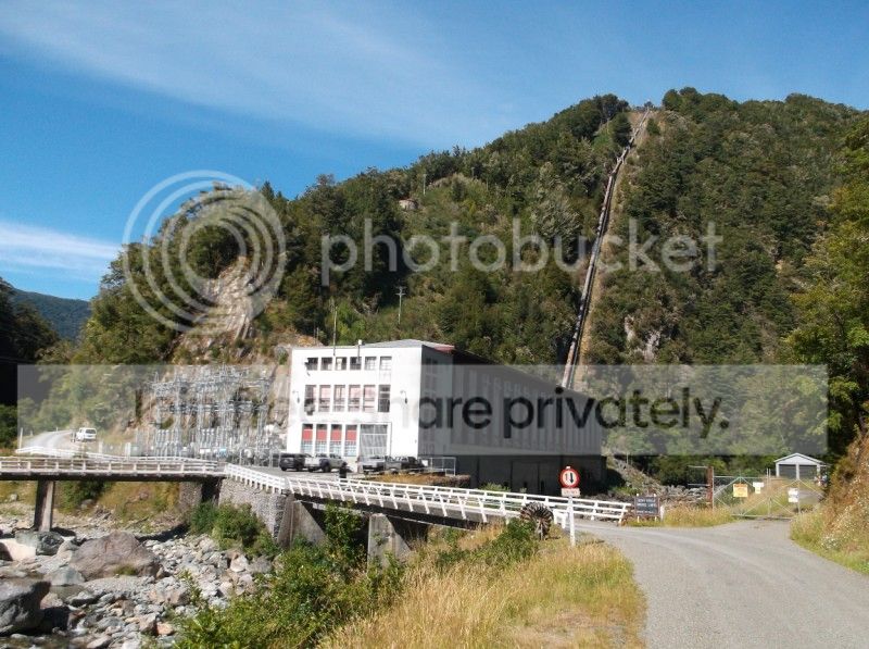
The start of the track:

The track is very easy to begin with, being an old road:


After an hour I reached an old asbestos mine:


The track continued going up:


I soon reached Asbestos Cottage, former residence of Mr and Mrs Chaffey, where I stopped for lunch:


I set off again and the track got narrower:


Climbing up the Bullock Track:

Introduced (pest) wasps feeding off the honeydew produced by scale insects living in the sooty mould on Beech Trees: http://sciencelearn.org.nz/Contexts/Hidden-Taonga/NZ-Research/Honeydew-ecosystem

From Red Beech to either Silver or Mountain Beech:


Up onto Peat Flat:

There was some protection from possums for some trees out in the middle of nowhere:


I then climbed up Peel Ridge with views of Cobb Reservoir:


Out of the forest and continuing up Peel Ridge:


Lake Peel is just around the corner:


Looking back:


Continuing on:


Gordon's Pyramid on the left, Mt Arthur in the middle and The Twins on the right. Balloon Hut is in one of the clearings on the right:

Looking West into the Leslie Karamea:

Balloon Hut:


One of the resident Weka:

I shared the hut with a great bunch of people and we played cards and other games.
So that was the first day. Did I warn you this thread is pic-heavy? -
<u>Tableland Circuit 1 Day 2: Balloon Hut - Cobb Dam Road</u>
From Balloon Hut I continued circuiting around Tableland:


Mt Arthur and The Twins:

Salisbury Lodge and Gordon's Pyramid:


Mt Arthur:

Pressing on, I visited Dry Rock Shelter:


Growler
 Shelter:

Crossing a swingbridge at Upper Junction:

This next section of track is also used by mountainbikers. They must have riled up some wasps as I got stung by one after they passed through.
Another swingbridge to cross, this one at Lower Junction:


After this I rejoined the track I was on yesterday and went back past Asbestos Cottage and the asbestos mine and out to the road.
Day 1 was about 8 hours including lunch.
Day 2 was less, maybe about 5 hours?Lastly, a souvenir:







 for makin' me


Hello! It looks like you're interested in this conversation, but you don't have an account yet.
Getting fed up of having to scroll through the same posts each visit? When you register for an account, you'll always come back to exactly where you were before, and choose to be notified of new replies (either via email, or push notification). You'll also be able to save bookmarks and upvote posts to show your appreciation to other community members.
With your input, this post could be even better 💗
Register Login


